By Austyn Gaffney / High Country News
On a hot, dry, windy summer morning in 2014, rancher John Bailey drove along the edge of a wildland fire in southeast Montana. The fire had started inconspicuously — no lightning strike or neglected campfire involved, just flames appearing on open range owned by Jared Broadus, Bailey’s cousin. The county’s official fire warden was stationed about an hour away, so Bailey, 53 at the time and Rosebud County’s volunteer fire chief, drove a state-owned pickup out to check on the fire line. The blaze was small, only a few acres, and Bailey, who had fought fires his entire life, wasn’t worried. He didn’t own any fire gear, so he wore his regular ranching clothes: jeans and a Stetson that shaded his eyes as he looked across the valley below, where slabs of beige rock the size of three-story houses littered the landscape.
Here in the high desert, generations of rivers — the Yellowstone, the Powder and the Tongue — had eaten into the soft sandstone, leaving a fortress of ochre and amber walls, webbed by steep escarpments and narrow drainages. Black Angus roamed between them, the calves running on their tippy legs. The whole eroding country looked like it was settling, like someone sinking into the folds of a giant armchair. Bailey drove slowly through the smoke from the fire, trading jokes with another cousin, Pat Bailey, who rode shotgun.
They were driving through a smoky gap — the fire line on their right, and a steep drainage, the Rough Draw, that dropped to a 60-foot-deep ravine to their left — when the ground beneath them suddenly disappeared. Ghostly fumes rose up from the space where two men and the pickup had been just moments before.
Inside the pickup, shaken but unhurt, Bailey looked through a windshield at a world now split between earth and sky. The truck had sunk into dry yellow grass, as though the ground they’d been driving on had eerily, and swiftly, deflated. The two men rolled down their windows and scrambled out of the truck, crawling back up to soil that was hot to the touch. The truck’s tires were smoking, and the rotten-egg smell of sulfur and ash poured out of tiny fissures surrounding the sinkhole.
The moment the truck was swallowed, Bailey knew what had happened: They’d fallen into a sinkhole created by a burning coal seam, a type of fire that starts on natural outcrops of coal before quickly moving belowground, eating through seams that can range in thickness from a few inches to dozens of feet. Once underground, these fires become extremely difficult, if not impossible, to extinguish.
Locals like the Baileys were familiar with these fires; the area had long been nicknamed Coal Seam Alley. But the fires were changing, becoming more common and more dangerous, and foretelling a new era of climate catastrophe in southeast Montana — an era in which devastating wildfires were no longer caused just by humans or lightning, but also by the fires below.
COAL SEAMS, glinting ribbons of flammable ore that unspool across every continent except Antarctica, have caught fire for millions of years. They ignite on the surface, sparked by lightning or nearby wildfires, or through spontaneous combustion. They devour the surface coal and burrow deep belowground where they continue to smolder, lasting anywhere from a few years to centuries; Australia’s Mount Wingen has been burning underground for at least 6,000 years. While there are hundreds of underground fires in the Western United States, many are concentrated in the Powder River Basin, a lung-shaped swath of southeast Montana and northeast Wyoming.
This area is the world’s largest known coal reserve, containing the nation’s largest coal mines, though many of the seams in the rugged landscape are too thin and unreachable to attract mining companies. For at least 4 million years, the basin has naturally burned through its coal bed, baking the sediment above into red-brick stone known as clinker, which the locals call scoria because it resembles volcanic rock. Today, about 7% of the hills and ridgelines in the basin are capped by clinker, the product of tens of billions of tons of burnt coal.
Subterranean fires have been observed in Montana for at least 200 years and likely longer; the Cheyenne and Crow tribes have lived in the area for millenia. In the early 19th century, William Clark documented the coal fires, noting the relationship between clinker and exposed coal seams along the “burnt” hills. A coal seam fire called the Burning Coal Draw fire was one of the longest-lasting recorded in the region. It was first documented by a military expedition in 1870, and was still burning around World War II, when one Wyomingite described it as sounding “like the roar of a freight train — on its good days.” It was finally extinguished in 1951 by the now-defunct U.S. Bureau of Mines. But for the most part, the ranchers, like the tribes, regarded the underground coal fires as a normal part of life, like rainstorms and winter.
They are easiest to spot in the winter; telltale signs include a patch of snow melt, steam hissing from a vent, a blackened edge of burnt ground. In the summer, the stench of sulfur gives them away. Over time, they often form a ring or a crescent moon as the surface sloughs off around the vent. Sometimes, embers glow as the fire tunnels into the earth. Eventually, this tunnel can collapse, weakened by wind, rain and erosion, becoming a sinkhole like the one Bailey’s truck fell into. The coal can burn until either the coal seam ends, starving the fire, or the overburden buries it, depriving the fire of oxygen and snuffing it out.
But the fire can also keep growing, gnawing its way back toward the surface, fueled by oxygen and aboveground vegetation, until it finally breaks free and — sometimes — erupts into a raging wildfire.
Today, coal seam fires, like other wildfires, are becoming more common and more destructive.
Since the early 20th century, the temperature has risen 2.5 degrees Fahrenheit. Meanwhile, the frequency of Montana wildfires has almost doubled since 2002, according to the National Interagency Fire Center. In Montana, tribal members, ranchers, firefighters and local officials all report a dramatic increase in the number of naturally occurring coal seam fires.
In 2021, local officials estimated that 60% of Rosebud County’s roughly 70 wildland fires were ignited by coal seams. According to the Bureau of Indian Affairs, 80 active coal seams at Northern Cheyenne have caused, on average, five wildfires per year. But data collection by the county, state, tribal and federal offices is neither regulated nor coordinated. Montana’s Department of Natural Resources and Conservation recorded an increase in coal seam fires from 14 to at least 200 across seven counties between 2000 and 2021, a 1,400% increase, but only started actively looking for coal seam fires in 2011.
Then, last August, the largest-known wildfire ever ignited by a coal seam ravaged 170,000 acres of Rosebud County and the Northern Cheyenne Reservation. The Richard Springs Fire was the largest wildland fire in Montana last year. It took two weeks to fully contain and cost the sparsely populated region at least $30 million.
The dramatic increase of fire activity in the West could mean that wildfires are reaching, and igniting, more coal seams, while the hot, dry weather causes more seams to spontaneously combust. Fire activity here creates a feedback loop: Wildfires ignite coal seams, coal seams ignite more wildfires, and so on. But since coal seam fires aren’t comprehensively tracked, the extent of the problem remains theoretical.
“We have always had a handful of coal seam fires in this country, just because there’s coal and it’s exposed,” Jared Broadus, John Bailey’s cousin, said. “But we’ve never had an issue with them like we do now.”
Science has yet to determine if the increase is caused by climate change, partly because it has seldom paid much attention to coal fires at all. Ed Heffern, a now retired geologist for the Bureau of Land Management, is one of the few scientists who have studied coal seam fires in the U.S. He began learning about them in the 1970s, after moving to Lame Deer, the tribal headquarters of the Northern Cheyenne Reservation: While cross-country skiing, he noticed mysterious puffs of smoke rising along the horizon. One day, when the temperature hovered around zero, he moved carefully around a patch of bare ground, hot to the touch and emitting sulfurous fumes, surrounded by a foot or two of snow.
By the early aughts, Heffern’s research showed that the clinker-capped hills had begun forming millions of years ago, when temperatures zigzagged between warm and cold cycles. Most of the clinker hardened during the warmer interglacial periods, indicating that more coal fires occurred when the climate was hotter — as it is today.
“I wouldn’t be surprised” if the increase in coal seam fires was caused by climate change, Heffern told me last spring. “But it’s a conclusion based on limited data.” Glenn Stracher, a geologist and another of the few experts on the subject, agrees that the signs point toward a connection.
Given the lack of reliable information, the Custer County fire department has decided to step up and build a data set of its own, tracking coal seam fires across five southeast Montana counties, including Custer and Rosebud, Custer’s neighbor to the east, as well as the Northern Cheyenne Reservation. The fire department hopes to show that the region needs help, and money, to deal with the growing problem.
“THE LAST FOUR OR FIVE YEARS, it’s been fire years, it hasn’t been fire seasons,” Cory Cheguis, the 30-year-old fire warden of Custer County, said in early May. Clad in a Montana State University T-shirt, sunglasses balanced on his baseball cap’s brim, Cheguis guzzled gas station coffee at 8 a.m. as we left his firehouse in Miles City, the county seat, and drove south toward the town of Broadus, in Powder River County. Cheguis, who started working for Custer County in 2015, has fought fires in the region since he was 12.
When wildland fires strike in the rural West, volunteers from all over the region drive their “ranch rigs” — souped-up firefighting pickups carrying 200-to-500-gallon water tanks — toward the flames. Cheguis has fought fires for both Custer and Rosebud counties and he’s done state-level rotations, even traveling to Southern California for the 2019 Maria Fire.
Until recently, he explained, wildland fires ignited by coal seams have been dealt with by landowners and tribal members on a case-by-case basis. If a burning coal seam appeared likely to spark a wildfire, the locals might build a fire line around it and monitor it; if a wildland fire then started, they would extinguish the surface flames, trace the ignition source back to the coal seam and watch it even more closely. Extinguishing the coal seam fire itself was often too dangerous and expensive to tackle without tribal, state or federal assistance.
But then the issue exploded. Like many others I spoke to, Cheguis traced the increase in burning coal seams to the spring of 2011, when heavy rains greened up the flowering yellow sweetclover till it towered six feet tall. When drought hit the following summer, the vegetation turned to tinder, and a trio of lightning-caused fires in 2012 — the Chalky, the Rosebud Creek Complex and the Ash Creek, the sixth-largest fire in the West that year — burnt over 550,000 acres of southeast Montana and ignited a whole new generation of coal seam fires.
“Then, in the spring of 2015, all hell broke loose,” said Rosebud County fire warden Rodney Dresbach. He started getting calls about fires that started without lightning or evidence of human involvement. “During the months of March and April, we were running on coal seam fires about every three to four days.”
Cheguis saw firsthand the problems caused by the increasing number of fires. But nobody seemed to be tracking them, and the lack of data meant no one knew the extent of the problem, he said. Stracher, the geologist, agreed: “Unfortunately, there aren’t more people in the U.S. studying these fires.”
So, in October 2021, after last summer’s Richard Springs Fire, Cheguis called a stakeholders meeting. He expected a dozen people, but 50 local officials, ranchers and tribal members crowded into the Miles City Fire Hall, and more attended via Zoom. They came from all over Montana’s southeastern pocket — Rosebud, Custer, Powder River, Treasure and Big Horn counties, and the Northern Cheyenne Reservation. At the meeting, Cheguis unveiled his plan: to map every coal seam fire in a 10,000-square-mile region using infrared cameras, and create a data set for all five counties and the Northern Cheyenne Reservation.
Over the last century, inventorying coal seam fires has been sporadic at best: Between 1948 and 1958, the Bureau of Mines recorded 177 coal seam fires across the West and Alaska, while in 2013, Heffern, the BLM geologist, counted 53 natural coal fires in the Powder River Basin. During four months in 2022, Cheguis recorded 1,684 hot spots — infrared pinpoints, most of which he believes will be verified on-the-ground as burning coal seams — across a tiny fraction of the area studied between 1948 and 2013. He estimated that the final tally will be closer to 3,000. Montana’s Abandoned Mine Lands office donated an ArcGIS mapping program, and in late June, Cheguis received a $400,000 grant from the Federal Emergency Management Agency.
Among the October meeting’s attendees were two volunteer firefighters — Myles Gardner and Clint Pedersen — who knew that Cheguis’ initial aerial maps would require verification, or ground-truthing, to confirm that every hot spot the infrared cameras found was actually a coal seam, not an extremely hot rock or solar panel. The process would also provide each location’s GPS coordinates, along with details like the seam’s size, its position on a slope and its access points. Verification would lead to prioritization: How high a risk was this particular coal seam? Were there embers near the surface, or tree roots smoldering belowground? Was the area particularly windy and inclined to shoot sparks?
Pedersen, a compact 56-year-old who ran the Broadus veterinary clinic and served as Powder River’s assistant fire chief, and Gardner, a lanky 33-year-old volunteer firefighter, rancher and hunting guide, believed that drones would be the easiest way to ground-truth the hundreds of hot spots in rough country. So that winter, they spent hours on YouTube learning to fly drones, and in the early spring, began working closely with Cheguis, while discovering additional burning coal seams.
An hour after leaving Miles City, we pulled up to Pedersen’s clinic in the one-street town of Broadus. After a round of handshakes, I climbed into Gardner’s dark blue Chevy Denali, with a spare tire roped to the roof, a cellphone booster bobbing off the hood and a pile of Vienna sausage cans rolling on the floorboard, while Cheguis and Pedersen trailed us in the truck. Six miles south of Broadus, we turned onto the Randall Ranch, where Gardner and Pedersen had found 36 active coal seam fires in a 25-acre bowl of ridges and ravines. Cheguis’ flyover of the same region the winter before — thousands of feet above the height a drone could go — hadn’t found any.
“That’s how scary this is, how many more we know about than what the plane sees,” Gardner said. Here, we saw the first of what would be almost a dozen burning coal seams that day. Gardner advised us to be alert around the loose earth surrounding a vent. When I touched the ground, it radiated heat like a sunburn. Pedersen pulled out two plastic bins from the trunk, which held thousands of dollars’ worth of drone equipment. Between January, when they launched their new business, CM Thermal and Fire, LLC, and our visit in May, Gardner and Pedersen had pooled $55,000 to buy seven drones, four with thermal imaging. They’d already found at least 750 coal seams in three-quarters of Powder River County alone.
Cheguis, Gardner and Pedersen knew of just two tactics for lessening the risk of coal seam fires: Excavate the coal and fill in the resulting chamber with nonflammable soil, extinguishing the fire, or create a 10-to-100-foot-wide buffer line, which might include logging and chemically spraying the land, to limit the chance of igniting a wildland fire. Gardner thought a parcel this size — 25 acres — might require both logging and spraying the entire acreage, turning the area back to dirt, so no spark could set the hillside aflame. In lieu of those solutions, the region simply deals with wildland fires ignited by coal seams as they come.
Above us, their newest drone shot up into the air — tiny and unnerving in the intelligent precision of its movements. Its four buzzing propellers swooshed the grass below as it moved off to inspect a pair of horseshoe-shaped coal seams to the east. Meanwhile, Gardner sent up what he called their “workhorse,” a drone so small and delicate you could easily mistake it for a bird. His controller, a black screen a little larger than a deck of cards, showed an infrared map, with a red spot reading 250 degrees Fahrenheit about 100 feet above a coal seam-looking crack.
About 20 feet from where I’d investigated the first vent, a second one spewed sulfur from the side of a cliff. The ground between the two vents felt solid, but Pedersen said they were likely connected, chewing away at the coal underneath us and hollowing out the hillside. Coal seam fires move from an outcropping to the subsurface quickly, and because there are virtually no regulations on how to handle them, there are no public safety measures. Standing atop one is spooky at best, deadly at worst.
“What do they call it in the Bible?” Pedersen asked later, pushing up his glasses as we hiked a draw toward another coal seam, a boxed-up drone knocking against Gardner’s knees like a briefcase. “Brimstone,” he answered himself. “Hellfire, and brimstone.”
CHEGUIS, LIKE MANY LOCALS, believes that the coal seam fires have been ignored at the federal level. But from the mid-20th century until the early aughts, the U.S. government has periodically intervened in what it terms “coal-crop fires” — naturally occurring blazes that begin on unmined coal outcrops.
In 1948, the Bureau of Mines began tackling fires from inactive coal deposits through a Department of Interior Appropriations Act. By 1958, the agency had investigated 126 of the 177 coal fires documented across 19 states in the Western U.S., the majority in Montana.
The agency’s firefighting tactics mirrored Cheguis’ approach: excavation and replacement with clean fill dirt, isolating the burning area from the main coal bed, or smothering the fire and compacting the earth up to 35 feet beyond the active embers. Each fire required at least three years of patrolling, inspection and maintenance before it was considered extinguished. The agency spent over a million dollars to put out 40 fires, noting that accessibility and cost often determined its priorities. It argued that the program should continue, citing the “conservation of coal resources and preservation of property.”
“It was on the radar screen many, many years before you and I were born,” Heffern, who’s 72, told me. The federal government knew about coal seam fires, he said, and “they were concerned about it way, way back then, but it just — lost the funding.”
Funding is now even patchier. After the Bureau of Mines dissolved in 1996, the Abandoned Mine Lands Division of the North Dakota Public Service Commission used almost $170,000 in federal funding to suppress 60 naturally occurring coal-crop fires between 2003 and 2012 on state and federal land underlain by lignite coal.
The costs were authorized by a special grant, part of a cooperative agreement between the U.S. Forest Service and the Interior Department’s Office of Surface Mining. But the program ended in 2012, and Joan Breiner, assistant director of North Dakota’s Abandoned Mine Lands Division, said the agency was no longer allowed to extinguish these fires and had stopped tracking them altogether.
Across the West, the number of agencies tracking coal seam fires, their funding methods for dealing with such fires, and their strategies for mitigation, if they exist, are complicated and hard to track, often isolated within bureaucratic silos.
“Montana is a complex checkerboard of jurisdictions that must work together to identify and share the collective responsibility of exploring improvements to coal seam fire detection and mitigation strategies,” Robyn Broyles, public affairs specialist for the Bureau of Indian Affairs, wrote in an email. “There is no one easy, single strategy.”
On the Northern Cheyenne Reservation, the Bureau of Indian Affairs monitors coal seam fires, managing them if they reach the surface, but not actively extinguishing them. Broyles wrote that the focus of BIA’s wildland fire prevention program was on preventing human caused wildfires, not naturally occurring fires that smolder in coal seams.
“Because firefighters don’t always know when or where coal seam fires that may be smoldering will rise to the surface, igniting grass or brush as it does, firefighters’ proactive measures are limited to mapping and monitoring known coal seam areas,” Broyles wrote. She added that BIA was appropriated funding “only for wildfires that consume burnable vegetation such as grass and timber.”
“From a tribal perspective, we just haven’t gotten that far yet,” Teanna Limpy, the tribal historic preservation officer in charge of the Northern Cheyenne’s archaeological and cultural sites, said. “Historically, we haven’t really done anything. We don’t dig up our ground. It’s not something we’ve had to make a hard decision on yet, but we’re going to have to because our fires are burning all the time.”
The Montana Legislature has also failed to address the problem, said Rae Peppers (Crow), who served eight years in the state House of Representatives. She helped pass a long-overdue firefighter pension plan, she said, but the lawmakers never discussed coal seam fires.
“We did support the firefighters,” Peppers said, “but we didn’t directly talk about coal seam fires. We should have.”
Today, Scott McAvoy, acting fire management officer for the BLM’s Eastern Montana/Dakotas District, said the BLM deals with burning coal seams solely on a case-by-case basis. Over the last decade, McAvoy has responded annually to an average of 20 wildfires ignited by coal seams, and as many as 50 in 2020 alone. Sometimes he’s had to respond to the same ignition point several times, because the fire isn’t always extinguished. If the coal seam is shallow, they can dig it out, but if it’s a larger project, they have to get both funding and regulatory approval, including federal reviews to ensure that no historic artifacts or endangered species are in the vicinity.
The lack of support has been frustrating to Rosebud fire warden Dresbach, who said the BLM “hadn’t done shit” about coal seam fires on federal property, including fires that impacted rural landowners. Without the proper regulatory approval, Dresbach lacks the jurisdiction to fight coal seam fires on BLM land, though when asked about it, he said bluntly, “I don’t give a rat’s ass about BLM at this point. I’m going to do what needs to be done.”
The Montana Department of Environmental Quality’s Abandoned Mine Lands Division has tried to help. Bill Snoddy, the program manager, said his agency has extinguished at least 16 coal fires in its 42-year history. The most recent coal seam fire Snoddy fought, in early January, took two weeks to extinguish. But before the agency can get the funding to deal with coal seam fires, his staff has to find evidence of historic mining, he said. Montana’s coal mines, which were established long before the state’s Abandoned Mine Lands program was born in August 1977, run the gamut of abandoned underground shafts to surface seams dug by homesteaders.
“If we can even make that tenuous of a connection, I can spend AML money on combating and putting out the coal seam fire,” Snoddy said. Putting out the over 1,600 coal seam fires Cheguis believes he has found so far would cost millions, said Snoddy, whose budget of $3.3 million has to cover the entire fiscal year. But if the burning coal seams aren’t mitigated, he said, disasters like the Richard Springs Fire could happen again.
The human impact of coal fires is often studied in conjunction with coal mines, instead of coal outcrops, since more funding is available and more regulatory tracking occurs. Glenn Stracher first learned about coal fires in Centralia, Pennsylvania, now a ghost town, where the nation’s largest and most destructive coal mine fire began in 1962. Later, Stracher visited eastern India, where the world’s largest coal mine fire has devoured 37 million tons of coal since 1916. Last year, the most destructive fire in Colorado’s history, the Marshall Fire — which destroyed over 1,000 homes and killed two people — was linked to an underground coal mine fire.
“There’s no question people have been negatively impacted,” Stracher said. Coal mine fires have caused horrific disasters: When seams have collapsed in India, Stracher wrote, buildings and people have been completely swallowed up by the newly created abyss.
In a 2010 edition of EARTH, he reported that the particulate matter and noxious gases from coal fires caused illnesses like strokes, chronic obstructive pulmonary disease and asthma, and advised anyone investigating such fires to wear protective clothing and a respirator. Broyles, of the BIA, said impurities like sulfur and nitrogen that are released when coal burns could expose wildland firefighters to toxic fumes, and because they lack appropriate protective equipment, he added, “Firefighters avoid directly engaging with burning coal.” The BLM’s McAvoy said that while many safety protocols for wildland fire suppression also apply to coal seam-ignited fires, his firefighters don’t wear respirators or special clothing either. Instead, he simply tries to use “extra caution” around coal seams to prevent injuries.
“This whole situation we have is a ticking time bomb,” Cheguis said. “I’m trying to take all this data above and beyond local government. This needs to be a federal issue.”
CHEGUIS ISN’T THE ONLY ONE seeking federal intervention. Two months after the Richard Springs Fire, while Cheguis formed his group in Miles City, Jeanie Alderson, a fourth-generation cattle rancher and former chair of the Northern Plains Resource Council, a statewide conservation and agricultural advocacy group, participated in a virtual hearing to address the issue underlying every coal seam fire: Who was responsible for putting these fires out, and for the damages they wrought?
Alderson, her dark curly hair tied back, testified before the House Committee on Natural Resources: “One of the challenges that my neighbors and I continue to face are large, uncontrollable wildfires on our ranches that are sparked from underground fires in federally owned coal seams.”
Fighting coal seam fires is expensive and dangerous, but Alderson said that the biggest problem was the threat they posed to the locals’ livelihoods by damaging grazing land, fences, livestock, buildings and water infrastructure. “Time and time again, it feels like private landowners are paying for damage to our property from minerals that belong to the federal government,” she said.
The Aldersons have ranched near the Tongue River, about 30 miles south of Ashland, since 1889. But beginning in the early 20th century, a series of federal acts created so-called “split estates,” meaning that, the surface rights — the grassland — and the mineral rights — anything minable belowground, especially coal — have divided ownership, largely to assist the U.S. government in maintaining coal rights while selling surface rights to Western landowners. Today, most coal rights, including one-third of U.S. reserves, are owned by the federal government, but in the Powder River Basin, it’s even more concentrated. Here, the federal government owns 77% of recoverable coal; 87% of private landowners own just the surface rights.
Back in 1958, before a burning coal seam could be mapped or mitigated, a preliminary investigation was done to determine who owned the coal rights, because “partial cost must be borne by the owner, if the fire is on privately owned coal,” read a 1958 Bureau of Mines report. But by the report’s publication, the Bureau had only managed fires on federal coal deposits, or fires endangering such deposits.
In May, sitting at his kitchen table, Alderson’s husband, Terry Punt, said that in order for the federal government to do something, “they almost have to be held liable.”
“That’s their asset, yet they’re paying no taxes on it,” Punt said, meaning the coal. “They’re paying nothing on it until they develop it. It’s sitting in the ground. Yet it could be doing somebody else a hell of a lot of harm.”
But ranchers also worry about the precedent it could set to make anyone, even the federal government, liable. No one owns the thunderclouds that produce lightning strikes. Coal outcrops are also natural, but unlike lightning, they can often be managed to reduce the chance of wildfires. If a property owner was aware of a burning coal seam and did nothing to put out or isolate the embers, and the embers started a fire, would they be liable?
“Who owns the bad dog that’s biting everybody?” Bailey asked. “Nobody wants to take ownership.”
Though the Rosebud County Sheriff’s Office fire report says the Richard Springs Fire began on the Broadus ranch, Broadus denies this, and the coordinates reported to Inciweb — an interagency information system for wildland fire — show that the ignition point was on land owned by Westmoreland Rosebud Mining, LLC. Broadus’ neighbor, Doug McRae, said mine officials told him earlier this spring that they knew about the burning coal seam a few days before it ignited the wildland fire on Aug. 8, and tried to suppress it with water. (The Westmoreland Mine did not respond to multiple requests for comment.)
“There was some talk about possibly pursuing it from a legal perspective,” McRae said. “But if you go there, then every time you have a coal seam fire that happens to break out, and you were aware of it, then you’re subject to the same concern, or the same liability, if you push it.”
DEALING WITH COAL SEAM FIRES becomes a cost-benefit analysis: Which is worse? Letting a coal seam burn and risking a bankruptable level of destruction if it spreads, or spending millions of dollars and risking unforeseen ecological impacts to put it out?
After a century of surface wildfire suppression, the blanket management suggested by the surrounding counties could just be another way of halting a naturally occurring process, with implications as yet unknown. Doug Martens, Rosebud County’s former fire warden and current county commissioner, said suppressing fires for so many years had prevented the natural fire cycle from taking place.
“We are probably our own worst enemies,” Martens said. “If we would have managed fire suppression years ago, the (Richard Springs) fire wouldn’t have gotten that big in the first place.”
It’s as if the vents are mouths through which the Earth is speaking to us, warning of trouble above and below and the imminent danger of climatic collapse. In southeast Montana, the testimony is regionally specific: The bedrock is eating itself. This geologic cannibalism is part of a natural cycle, leaving behind lines of clinker, brick pathways back in time. But the growing number of burns, and their frequency, could be another result of human intrusion. One wildland fire, under the right conditions, can propagate many coal seam fires, which can in turn ignite many more wildland fires. The only way to know whether it’s happening is if someone pays attention. But we tend to ignore the forge beneath the earth, until catastrophe strikes.
Martens said his own 30 years of firefighting had likely contributed to the problem of massive wildfires today. “But we have to put out the fire,” he added, “or people lose their livelihood.”
The Richard Springs Fire burned about 20,000 acres of the Broadus ranch, and about half of Bailey’s land last summer, while another coal seam fire, the Slough Grass Fire, took the rest. Bailey, like many local ranchers, had to sell his cattle early, cutting his herd by 100 head and spending $90,000 on additional hay — an unfunded budget item, since he typically grows and harvests his own.
“We don’t have time really to mitigate it like we should,” Bailey said. Between branding and putting spring crops in, he, his wife and his son can’t do it all. “It seems like we always have time to fight fire but never have time to mitigate.”
And McRae, who lost 217 cattle in the 2012 fires, and virtually all his grassland in the Richard Springs Fire, said that insurance doesn’t cover coal seam fires. “You get to be my age, and you think, is it really worth it?” McRae asked.
On Northern Cheyenne tribal land, Rae Peppers, the 66-year-old former legislator, and her husband, Jim (Northern Cheyenne), lost $30,000 in hay, fences and farm animals to the Richard Springs Fire.
“Every bit of it takes away from your livelihood,” Peppers said in May. Five days after the fire began last August, she and Jim raced through the suffocating heat to gather as many of their 70 head of cattle as they could find. Bombers the size of passenger planes looped overhead, releasing retardant in long pink horsetails. Tribal members drove around with loudspeakers, begging residents to take shelter at the local Boys and Girls Club or board a bus for the tribal school. Power, then water, and finally, cellphone service, all sputtered out.
That afternoon, as flames licked the hills above their house, dozens of firefighters, exhausted after almost a week of choking ash and little sleep, doused their yard with water. While a black bear escaping the flames cooled off beneath their sprinklers, the Peppers evacuated.
But that night, Rae Peppers couldn’t sleep. In all the chaos, she’d failed to call back their string of horses — 10 immensely strong, half-wild draft mares raised for generations by her husband’s family. One was Peppers’ saddle horse, Menoodle. She feared the airplanes had spooked the horses, sending them running toward timberline.
Peppers went home at 6 the next morning. The smoke was so thick, she drove the mile up her dirt road almost blind, navigating slowly, from reflector to reflector. At the cattle guard to a hayfield overlooking the hills, she opened the truck door, stumbled out and fell to her knees. Trees were charred into inky toothpicks, hay twisted together like matted hair across black dirt. And just half a mile away, all her horses were dead.
It wasn’t until early May, the night before our visit, that she finally went up to see where they died. Their bare white bones were laid out like yet another geologic layer, bright in the early evening light.
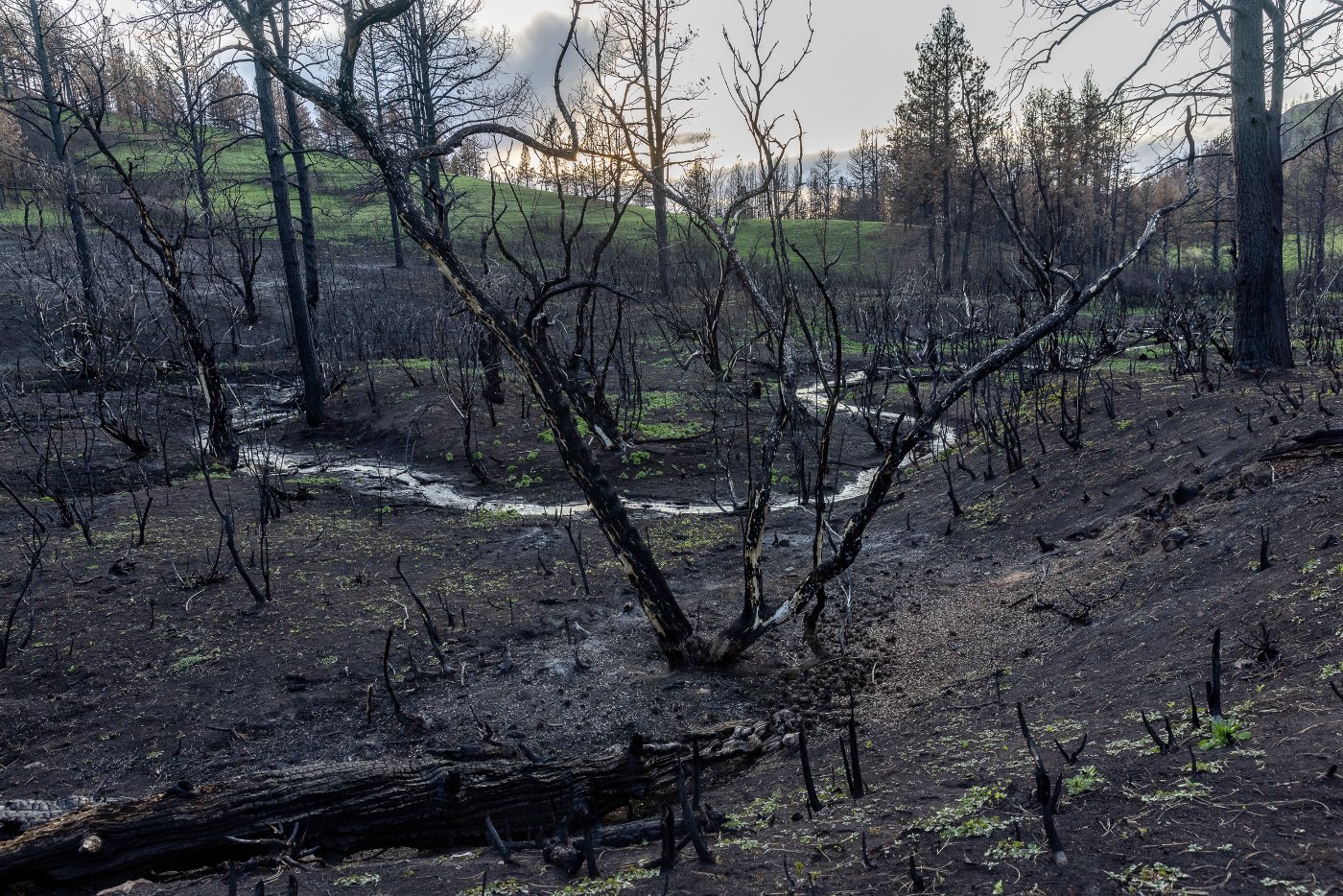
FEATURED IMAGE: Scorched earth and vegetation from the Richard Springs Fire behind the home of Rae Peppers. The wildfire, ignited by a coal seam, grew quickly, trapping and killing Peppers’ herd of draft horses. (Louise Johns / High Country News)
Austyn Gaffney is a freelance writer based in Kentucky covering climate, energy and culture. This reporting was supported by the International Women’s Media Foundation’s Howard G. Buffett Fund for Women Journalists.